EADA105 Exam Details
-
Exam Code
:EADA105 -
Exam Name
:ArcGIS Desktop Associate 10.5 -
Certification
:Esri Certifications -
Vendor
:Esri -
Total Questions
:80 Q&As -
Last Updated
:Jul 10, 2026
Esri EADA105 Online Questions & Answers
-
Question 61:
A GIS analyst needs to implement the requirements of a workflow that include field apps accessing feature services for data collection. The design calls for the analyst to build several feature templates that will be used by the feature services. Which item must be included in the feature template?
A. Database connection file
B. Group and query layers
C. Layer, Default tool, Attributes
D. Layers and tables based on views -
Question 62:
After being provided with 2 TB of aerial imagery from a vendor, an analyst must use the imagery to build a single dataset to be consumed within ArcGIS Desktop. However, the analyst must NOT duplicate any of the imagery due to storage constraints.
Which storage type is most appropriate?
A. Unmanaged Raster Catalog
B. Managed Raster Catalog
C. Mosaic Dataset
D. Raster Dataset -
Question 63:
Refer to the exhibit.
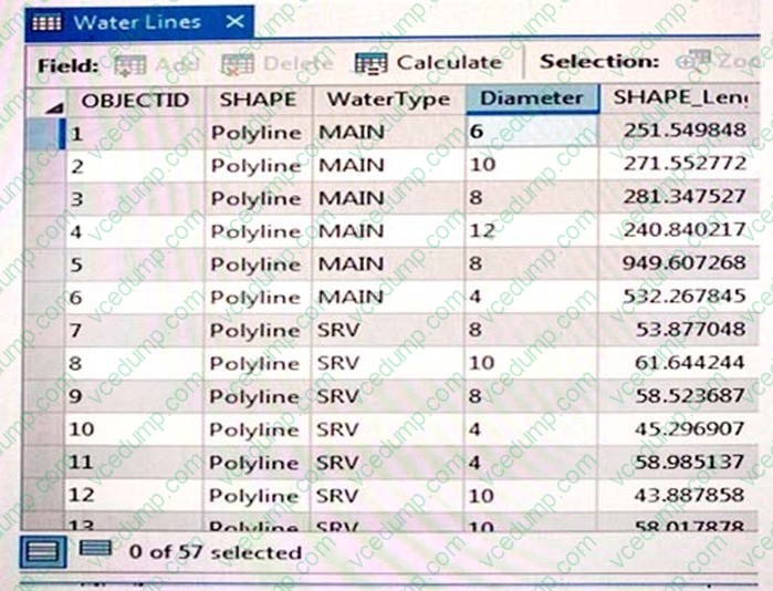
An engineering supervisor at a water utility asks the GIS analyst to find all pipes that are less than 10 inches in diameter. The analyst prepares a Select By Attribute query on the geodatabase feature class:
Diameter < 10
When validating this SQL query, the analyst gets the error: "There was an error with the expression."
What is invalid about the query?
A. Field name must be in enclosed in brackets: [Diameter]
B. Field name must be in enclosed in single quotes: 'Diameter'
C. Diameter is a text field but is using a numeric comparison
D. Query should include Diameter > 0 and < 10 -
Question 64:
A project calls for data published as a service to include all current ArcGIS metadata. How should an analyst make sure that the ArcGIS metadata is available with the service?
A. Update the service definition with the ArcGIS metadata
B. Copy the metadata XML document to the service metadata
C. Import the data into a geodatabase before publishing the service
D. Publish the data; ArcGIS metadata becomes the service's metadata. -
Question 65:
An ArcGIS user must share a map as a service to ArcGIS Online. The service must draw as fast as possible on a mobile device to provide fast display in the field. Which option should the user select in the capabilities of the service?
A. KML
B. Feature access
C. Tiled mapping
D. Mobile access -
Question 66:
An ArcGIS Pro user must be able to share work with a user in another organization to complete an analysis. The following items must be shared:
1.
Maps and the data referenced by their layers
2.
Toolboxes
3.
Geoprocessing history
4.
Attachments
Which package type meets the criteria?
A. Map
B. Layer
C. Project
D. Scene -
Question 67:
An ArcMap user is creating a new feature class that will participate in a geometric network. What should the user do so that the feature class is able to participate in a geometric network?
A. Make sure the feature class is z-enabled
B. Make sure that the line is the geometry type for the feature class
C. Make sure the feature class resides within a feature dataset
D. Make sure that a geographic coordinate system is assigned to the feature class -
Question 68:
A city planner is using ArcGIS to determine suitable areas that meet specific zoning criteria. The city's zoning polygon feature class has a ZONE attribute field that consists of one- or two-letter codes. What is the correct SQL statement to use to select all zones designated type E, F, or FF?
A. ZONE = 'E' AND ZONE = 'F' OR ZONE = 'FF'
B. ZONE IN ('E', 'F', 'FF')
C. ZONE = 'E' OR ZONE = 'F%'
D. ZONE CONTAINS ('E', 'F', OR 'FF') -
Question 69:
An editor has built map topology and needs to modify the shape of neighboring polygons. Which tool would maintain the shared polygon boundaries?
A. Reshape Edge Tool
B. Trance
C. Split Tool
D. Reshape Feature Tool -
Question 70:
A GIS analyst manages a layer of Park Boundaries and receives a table of Wildlife counts for different species in each park district. The analyst wants to create a permanent table association that allows for editing the wildlife information from within the park boundaries table.
Which type of table association should the analyst use to complete the task?
A. Relate
B. Simple Relationship Class
C. Join
D. Composite Relationship Class
Related Exams:
-
EADA10
ArcGIS Desktop Associate -
EADA105
ArcGIS Desktop Associate 10.5 -
EADE105
ArcGIS Desktop Entry 10.5 -
EADE19-001
ArcGIS Desktop Entry 19-001 -
EADP10
ArcGIS Desktop Professional -
EADP19-001
ArcGIS Desktop Professional 19-001 -
EAPA_2025
ArcGIS Pro Associate 2025 -
EGMA105
Enterprise Geodata Management Associate 10.5 -
EGMP2201
Enterprise Geodata Management Professional 2201 -
ESRI-EADA
ArcGIS Desktop Associate
Tips on How to Prepare for the Exams
Nowadays, the certification exams become more and more important and required by more and more enterprises when applying for a job. But how to prepare for the exam effectively? How to prepare for the exam in a short time with less efforts? How to get a ideal result and how to find the most reliable resources? Here on Vcedump.com, you will find all the answers. Vcedump.com provide not only Esri exam questions, answers and explanations but also complete assistance on your exam preparation and certification application. If you are confused on your EADA105 exam preparations and Esri certification application, do not hesitate to visit our Vcedump.com to find your solutions here.