Exam Details
Exam Code
:EADA105Exam Name
:ArcGIS Desktop Associate 10.5Certification
:Esri CertificationsVendor
:EsriTotal Questions
:80 Q&AsLast Updated
:Jul 02, 2025
Esri Esri Certifications EADA105 Questions & Answers
-
Question 21:
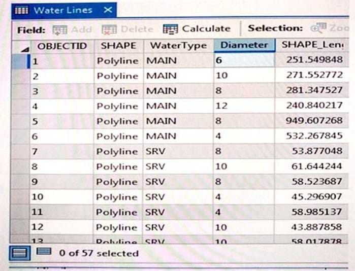
Refer to the exhibit.

An engineering supervisor at a water utility asks the GIS analyst to find all pipes that are less than 10
inches in diameter. The analyst prepares a Select By Attribute query on the geodatabase feature class:
Diameter < 10
When validating this SQL query, the analyst gets the error: "There was an error with the expression."
What is invalid about the query?
A. Field name must be in enclosed in brackets: [Diameter]
B. Field name must be in enclosed in single quotes: 'Diameter'
C. Diameter is a text field but is using a numeric comparison
D. Query should include Diameter > 0 and < 10
-
Question 22:
What property of a shapefile should an analyst be aware of when creating statistics from numeric fields?
A. Shapefiles do NOT support integer numbers
B. Shapefiles round to the nearest whole number.
C. Shapefiles change NULL values to zero.
D. Shapefiles CANNOT store currency values.
-
Question 23:
An ArcGIS Pro user must be able to share work with a user in another organization to complete an analysis. The following items must be shared:
1.
Maps and the data referenced by their layers
2.
Toolboxes
3.
Geoprocessing history
4.
Attachments
Which package type meets the criteria?
A. Map
B. Layer
C. Project
D. Scene
-
Question 24:
A project calls for multiple remote teams of 10 to 15 editors to work collectively and independently on a data editing project. Each team's work needs to be isolated for the duration of the edits. When the edits are complete, they must be merged into a centralized communal dataset that will be verified for quality.
Which geodatabase type would be best suited to this workflow?
A. Enterprise
B. File
C. Workgroup
D. Personal
-
Question 25:
Refer to the exhibit.

Which raster function will display image A as image B?
A. Shaded Relief
B. Slope
C. Hillshade
D. Aspect
-
Question 26:
An ArcGIS user has built a mosaic dataset using 25 rasters. However, upon adding the mosaic dataset to a blank map, the user finds that all rasters are NOT displaying. To troubleshoot the issue, the user zooms to the source resolution of one of the tiles and notices that the raster displays at 1:107000 but NOT at 1:997000.
Which tool needs to run to allow display of the rasters from 1:107000 to 1:997000?
A. Build Pyramids
B. Build Overviews
C. Build Footprints D. Build Boundary
-
Question 27:
An ArcGIS user creates a map of airline routes from a single city to several other cities. The user wants to indicate the relative flight times to reach the different cities.
What projection should be used?
A. Lambert Conformal Conic
B. Azimuthal Equidistant
C. Albers Equal Area
D. Eckert II
-
Question 28:
A GIS analyst has a point file that represents individual buildings with the following fields.
1.
Street Number
2.
Street Name
3.
Feature ID
4.
SHAPE
Which address locator style should be used with this type of reference data?
A. Single House
B. Dual Range
C. One Range
D. Street Names
-
Question 29:
When performing analysis in ArcGIS Online, which tool allows the GIS analyst to select features in the study area that meet a series of criteria based on spatial or attribute queries?
A. Derive New Locations
B. Find Similar Locations
C. Find Existing Locations
D. Create Viewshed
-
Question 30:
An ArcGIS user receives a file that contains global positioning system track information. The user must import that data to create polyline track features.
Which workflow will complete this task?
A. Table To Geodatabase > XY To Line
B. Points To Line > Dice
C. GPX To Features > Points To Line
D. Quick Import > Set Flow Direction
Related Exams:
EADA10
ArcGIS Desktop AssociateEADA105
ArcGIS Desktop Associate 10.5EADE105
ArcGIS Desktop Entry 10.5EADE19-001
ArcGIS Desktop Entry 19-001EADP10
ArcGIS Desktop ProfessionalEADP19-001
ArcGIS Desktop Professional 19-001EGMA105
Enterprise Geodata Management Associate 10.5EGMP2201
Enterprise Geodata Management Professional 2201ESRI-EADA
ArcGIS Desktop AssociateESRI-EADP
ArcGIS Desktop Professional 19-001
Tips on How to Prepare for the Exams
Nowadays, the certification exams become more and more important and required by more and more enterprises when applying for a job. But how to prepare for the exam effectively? How to prepare for the exam in a short time with less efforts? How to get a ideal result and how to find the most reliable resources? Here on Vcedump.com, you will find all the answers. Vcedump.com provide not only Esri exam questions, answers and explanations but also complete assistance on your exam preparation and certification application. If you are confused on your EADA105 exam preparations and Esri certification application, do not hesitate to visit our Vcedump.com to find your solutions here.