EADA105 Exam Details
-
Exam Code
:EADA105 -
Exam Name
:ArcGIS Desktop Associate 10.5 -
Certification
:Esri Certifications -
Vendor
:Esri -
Total Questions
:80 Q&As -
Last Updated
:Jul 10, 2026
Esri EADA105 Online Questions & Answers
-
Question 11:
A project calls for the creation of a single seamless raster dataset by merging 1000 separate rasters together. An analyst will use the Mosaic To New Raster tool to create the output. Adding the names of the 1000 rasters to the tool is a time-consuming task, so a model will be created to automate the process.
Which combination of ArcGIS Pro model utilities should be used to create a list of raster names that can be used as input for the Mosaic To New Raster tool?
A. Iterate Rasters and Collect Values
B. Iterate Files and Collect Values
C. Iterate Rasters and Select Data
D. Iterate Files and Select Data -
Question 12:
What property of a shapefile should an analyst be aware of when creating statistics from numeric fields?
A. Shapefiles do NOT support integer numbers
B. Shapefiles round to the nearest whole number.
C. Shapefiles change NULL values to zero.
D. Shapefiles CANNOT store currency values. -
Question 13:
Refer to the exhibit.
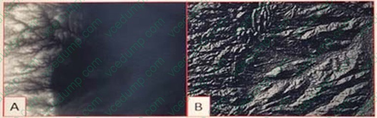
Which raster function will display image A as image B?
A. Shaded Relief
B. Slope
C. Hillshade
D. Aspect -
Question 14:
An ArcGIS Pro user has a 2D point layer of trees with a Height attribute in the attribute table.
What is the most efficient workflow for the user to display the trees in 3D with realistic appearance and height?
A. Add the layer and symbolize it with a realistic 3D symbol
B. Add the layer as a Preset Layer using realistic trees
C. Add the layer and extrude based on the Height attribute
D. Add the layer and convert it to a multipatch feature class -
Question 15:
An ArcGIS Online user is beginning to work on a project that will involve multiple organizations. Each organization has its own ArcGIS Online subscription. The project requires that only the project team have access to the data, and any team
member should be able to contribute to the project.
Which sharing option should the user select?
A. Everyone
B. Organization
C. Group
D. Organization and Group -
Question 16:
In ArcMap, how can a user project a layer without using a geoprocessing tool?
A. Right-click a file geodatabase > Import feature class (multiple)
B. Set the coordinate system of the data frame > Export Data with the coordinate system of the source data
C. Right-click a feature dataset with the correct coordinate system > Import feature class (Single)
D. Set the coordinate system of the data frame > Export Data with the coordinate system of the data frame -
Question 17:
How should an ArcGIS Pro user access web tools for analysis?
A. Share project as a web map and build a web app
B. Browse Portal tab for web tool and add to project
C. Download web tool from portal and run as Python
D. Add new model to project toolbox in Project pane -
Question 18:
An ArcGIS user has two feature classes. One is spatially inaccurate but contains accurate tabular data. The other is spatially accurate but contains inaccurate tabular data. The ArcGIS user needs a single feature class that incorporates the most accurate spatial and attribute data from both sources.
Which process should the ArcGIS user employ to accomplish this?
A. Join Fields
B. Transfer Attributes
C. Copy Features
D. Load Data -
Question 19:
A researcher is using ArcGIS Desktop. The researcher receives an assignment to create multiple printed map products with the same content but at different page sizes and map scales. What should the researcher use to perform this task?
A. ArcMap with the Toolshare folder structure and multiple map documents
B. ArcGIS Pro with content connections and multiple map layouts
C. ArcGIS Pro and import ArcMap documents from wherever the content was generated
D. ArcMap with multiple map documents for each map product graticule -
Question 20:
An ArcGIS user is creating a new water distribution network. In the water pipe feature class, fire hydrant laterals must have a pressure between 40 and 100 psi. Service water pipes must have a pressure between 50 and 75 psi. What must the user create to keep both pipe types in one feature class?
A. Relationship Rules
B. Coded Value Domain
C. Connectivity Rules
D. Subtypes
Related Exams:
-
EADA10
ArcGIS Desktop Associate -
EADA105
ArcGIS Desktop Associate 10.5 -
EADE105
ArcGIS Desktop Entry 10.5 -
EADE19-001
ArcGIS Desktop Entry 19-001 -
EADP10
ArcGIS Desktop Professional -
EADP19-001
ArcGIS Desktop Professional 19-001 -
EAPA_2025
ArcGIS Pro Associate 2025 -
EGMA105
Enterprise Geodata Management Associate 10.5 -
EGMP2201
Enterprise Geodata Management Professional 2201 -
ESRI-EADA
ArcGIS Desktop Associate
Tips on How to Prepare for the Exams
Nowadays, the certification exams become more and more important and required by more and more enterprises when applying for a job. But how to prepare for the exam effectively? How to prepare for the exam in a short time with less efforts? How to get a ideal result and how to find the most reliable resources? Here on Vcedump.com, you will find all the answers. Vcedump.com provide not only Esri exam questions, answers and explanations but also complete assistance on your exam preparation and certification application. If you are confused on your EADA105 exam preparations and Esri certification application, do not hesitate to visit our Vcedump.com to find your solutions here.