Exam Details
Exam Code
:EADP19-001Exam Name
:ArcGIS Desktop Professional 19-001Certification
:Esri CertificationsVendor
:EsriTotal Questions
:93 Q&AsLast Updated
:Jun 30, 2025
Esri Esri Certifications EADP19-001 Questions & Answers
-
Question 31:
An ArcGIS user finds consistently returned low matches tor addresses which refer to "River" abbreviated as "RVER". In order to improve their matches the "RVER" abbreviation needs to be added to the xml file in the geocoding rule base. Which two tools can be used to ensure these changes will be reflected before performing a new geocode? {Choose two)
A. Geocode Addresses tool
B. Create Address Locator tool
C. Rematch Addresses tool
D. Rebuild Address Locator tool
E. Standardize Addresses tool
-
Question 32:
An ArcGIS user has multiple tables that must be input into a single model. What can the user add to the model to automate the model to run on all tables?
A. Environment variable
B. Iterator
C. parameter variable
D. precondition
-
Question 33:
An ArcGIS user processes a point feature class using the Collect Events tool. The user finds that the output value for each feature is 1. Why did the tool only produce values of 1?
A. NONE of the points are co-located
B. mere is only one event to collect
C. All points are within a standard distance of one other point
D. The total value of all events adds up to 1
-
Question 34:
A user wants to connect new laterals to supply water to newly built houses. What edge type supports this function?
A. an edge between two junctions
B. a complex edge
C. a subtype of edge
D. a simple edge
-
Question 35:
An ArcGIS user has overlayed two polygon feature classes to produce an output feature class with the following user-managed attributes:
Soil_Code Aquifer_Type SuitabilityClass
Which geoprocessing operation should the user perform in order to combine the polygons of the output feature class based on the Suitability_Class attribute value?
A. Aggregate Polygons
B. Merge
C. Dissolve
D. Erase
-
Question 36:
A Microstation.dgn file is created for a mountainous area and is added to ArcMap with another vector dataset in the same projection. The .dgn file appears slightly too large in relation to the other data.
What is the most likely source of the problem?
A. Units of measure were incorrect
B. The file was created in ground coordinates
C. incorrect datum was assigned in the projection file
D. The file was created in grid coordinates
-
Question 37:
Refer to the exhibit.
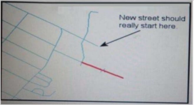
An ArcGIS user added a new street (shown in the exhibit) to a streets feature class within an edit session.
The new street seems to have snapped to an existing street but upon zooming in the ArcGIS user notices that the street is connected to the wrong street.
What is the most likely reason for this error?
A. The street was digitized at a scale that was too small
B. The street was digitized at a scale that was too large
C. The snapping tolerance was set to Low
D. Edge snapping was turned on Instead of end snapping
-
Question 38:
ArcGIS user is updating all the newly paved roads after some recent constructions. The snapping tolerance is set to 15 pixels. They zoom out to the full extent to see their progress. What should the ArcGIS user do next to maintain the accuracy of their editing?
A. increase the snapping tolerance
B. return to the previous scale
C. increase the sticky move tolerance
D. increase the thickness of the roads
-
Question 39:
An ArcGIS user is creating a script tool to automate a common workflow.
Which tool property ensures that the tool only recognizes intended feature data sources?
A. output spatial reference property
B. data type fitter property
C. workspace data property
D. data extent property
-
Question 40:
An ArcGIS user adds two feature classes with different coordinate systems in ArcMap. one at a time. The user starts editing data from the second feature class and is warned about editing the feature class because the coordinate system is different from the data frame.
Where do the edits occur?
A. In the data frame's coordinate system
B. In the feature's coordinate system
C. In an azimuthal equidistant coordinate system
D. In a geographic coordinate system
Related Exams:
EADA10
ArcGIS Desktop AssociateEADA105
ArcGIS Desktop Associate 10.5EADE105
ArcGIS Desktop Entry 10.5EADE19-001
ArcGIS Desktop Entry 19-001EADP10
ArcGIS Desktop ProfessionalEADP19-001
ArcGIS Desktop Professional 19-001EGMA105
Enterprise Geodata Management Associate 10.5EGMP2201
Enterprise Geodata Management Professional 2201ESRI-EADA
ArcGIS Desktop AssociateESRI-EADP
ArcGIS Desktop Professional 19-001
Tips on How to Prepare for the Exams
Nowadays, the certification exams become more and more important and required by more and more enterprises when applying for a job. But how to prepare for the exam effectively? How to prepare for the exam in a short time with less efforts? How to get a ideal result and how to find the most reliable resources? Here on Vcedump.com, you will find all the answers. Vcedump.com provide not only Esri exam questions, answers and explanations but also complete assistance on your exam preparation and certification application. If you are confused on your EADP19-001 exam preparations and Esri certification application, do not hesitate to visit our Vcedump.com to find your solutions here.