Exam Details
Exam Code
:EADP19-001Exam Name
:ArcGIS Desktop Professional 19-001Certification
:Esri CertificationsVendor
:EsriTotal Questions
:93 Q&AsLast Updated
:Jun 30, 2025
Esri Esri Certifications EADP19-001 Questions & Answers
-
Question 81:
An ArcGIS user is creating a processing environment that will be used repeatedly. To confirm results, the user wants to visualize the output of Intermediate processes during testing. The user is working with large data sets and wants to preserve already-complete steps and focus on one problem at a time.
Which geoprocessing approach should the user consider?
A. a Python script tool commenting out code blocks and functions as development progresses
B. the Python window saving the contents to a script when each processing step is confirmed
C. a stand-alone Python script executed in PythonWin with print statements capturing ArcPy messages
D. ModelBuilder running processes step-wise and displaying intermediate results in ArcMap
-
Question 82:
An ArcGIS user wants to symbolize the intersections of highways and streets so that the road casing symbols can be blended together to represent connectivity, but not blended in other situations to represent disconnectivity (e.g. where a
highway passes under a surface street).
What should be used to ensure that the road casings connect correctly?
A. symbol-level drawing with the join option
B. symbol-level drawing with the merge option
C. multi-layered symbol with one layer wider than the other
D. single layered symbol with two offset lines
-
Question 83:
After the ground water is the local community was contaminated by a landfill, the health department requested a map showing the cancer rate for each postal code. An ArcGlS user Is provided a file geodatabase feature class (FeatureClassA) that has been joined to a cancer rate table (TableB). The cancer rate table does not have data for each postal code In the study and also contains data outside the study area creating null values. To eliminate the null values from being symbolized.
Which exclusion query should be used?
A. (FeatureClassA OBJECTED is Not Null) and (TableB.cancerrate Is Not Null)
B. ("FeatureClassA OBJECTED" is Not Null) and (TableB.cancerrate is Not Null)
C. ("FeatureClassA OBJECTED". "TableB cancerrate" is Not Null)
D. ("FeatureClassA OBJECTED" and "TableB cancerrate" is Not Null)
-
Question 84:
While attempting to geocode schools within a 20-mile of a museum, an ArcGIS user realizes that the table they are trying to geocode only contains the names of the schools. The table tails to include the school addresses.
Which type of table should the user link to their address locator in order to efficiently display the locations of the schools?
A. A composite alias table
B. An alternate name table
C. A primary name table
D. A place name alias table
-
Question 85:
An ArcGIS user plans to distribute a series of map documents where the amount of time the map file can be viewed is limited. Which format should the user create to specify a timeout period for these maps?
A. mpk
B. ipk
C. pmf
D. msd
-
Question 86:
An ArcGIS user needs to create a map of flood zones for an insurance company. The user has a choice of four elevation data sets to perform the analysis.
USGS 30-meter DEM SRTM 90-meter DEM Lidar 5-meter DEM 30-meter DEM derived from stereo imagery
Which type of elevation dataset will create the most accurate flood zones?
A. USGS 30 meter DEM
B. SRTM 90 meter DEM
C. Lidar5-meter DEM
D. 30-meter DEM derived from stereo imagery
-
Question 87:
When rematching geocoding results, a user notices that E St Is being interpreted as East St. How snould a user resolve this Issue for future geocoding?
A. remove the entry defining E to mean east In the geocoding XML files
B. recreate the address locator with new reference data
C. create a composite address locator where E is not recognized as east
D. change E to east in the input table to be geocoded before geocoding
-
Question 88:
Refer to the exhibit.
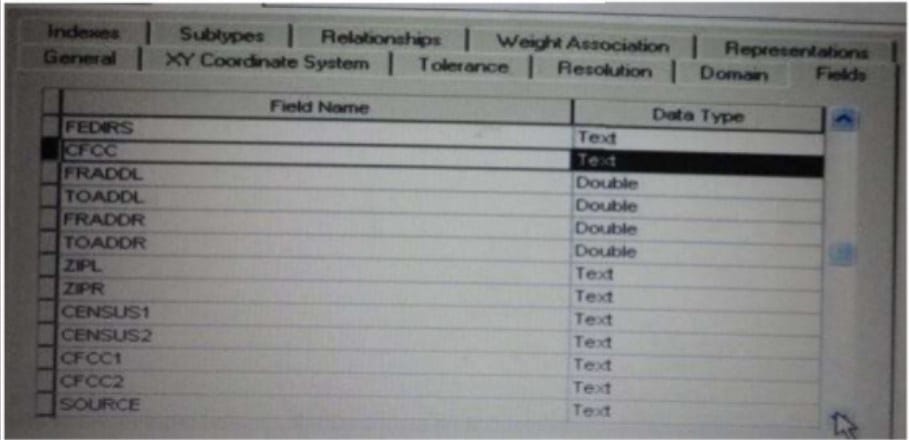
Which change needs to be made to the table in the exhibit in order to create subtypes based on the CFCC field?
A. A new field should be created to migrate the text values of CFCC to integers
B. A default CFCC value should be assigned
C. The data type of the CFCC field should be changed to Long integer
D. The allow subtypes property should be set to True
-
Question 89:
An ArcGIS user creates a map showing the level of human Impact on the natural landscape. Major habitat types are shown with unique colors, and the level of disturbance for each habitat Is shown with a graduated symbol. What is this type of map symbology?
A. Multisymbol
B. multivariate
C. unique value many fields
D. proportional symbol
-
Question 90:
An ArcGIS user has a soils polygon shapefile.
Which conversion is necessary in order to ensure that the soil polygons do NOT overlap or have gaps?
A. converting the shapefile to a stand-alone polygon feature class within a geodatabase
B. converting the shapefile to a polygon=feature class within a geodatabase feature dataset
C. converting the shapefile to a raster dataset within the geodatabase
D. converting the shapefile to a terrain dataset with the geodatabase
Related Exams:
EADA10
ArcGIS Desktop AssociateEADA105
ArcGIS Desktop Associate 10.5EADE105
ArcGIS Desktop Entry 10.5EADE19-001
ArcGIS Desktop Entry 19-001EADP10
ArcGIS Desktop ProfessionalEADP19-001
ArcGIS Desktop Professional 19-001EGMA105
Enterprise Geodata Management Associate 10.5EGMP2201
Enterprise Geodata Management Professional 2201ESRI-EADA
ArcGIS Desktop AssociateESRI-EADP
ArcGIS Desktop Professional 19-001
Tips on How to Prepare for the Exams
Nowadays, the certification exams become more and more important and required by more and more enterprises when applying for a job. But how to prepare for the exam effectively? How to prepare for the exam in a short time with less efforts? How to get a ideal result and how to find the most reliable resources? Here on Vcedump.com, you will find all the answers. Vcedump.com provide not only Esri exam questions, answers and explanations but also complete assistance on your exam preparation and certification application. If you are confused on your EADP19-001 exam preparations and Esri certification application, do not hesitate to visit our Vcedump.com to find your solutions here.