Exam Details
Exam Code
:EADP19-001Exam Name
:ArcGIS Desktop Professional 19-001Certification
:Esri CertificationsVendor
:EsriTotal Questions
:93 Q&AsLast Updated
:Jun 30, 2025
Esri Esri Certifications EADP19-001 Questions & Answers
-
Question 21:
An ArcGlS user maintains a street signpost database with measure in terms of two route feature classes: distance from the nearest school and distance along the street.
If the two feature classes are created from the same source line feature class, which geoprocessing tool will support calculating one event from the other?
A. Transform Route Events tool
B. Overlay Route Events Tool
C. Locate Feature along Routes tool
D. Near tool
-
Question 22:
AnArcGIS user is tasked with editing a layer containing a large number of features, using another layer thatis in a different coordinate a system as reference. The user adds the layers in ArcMap and starts an editsession. A warning message about editing data in a different coordinate system is displayed.
What is the most efficient way to edit the data to avoid potential distortion in the data?
A. change the data frame's coordinate system to match the coordinate system of the layer being edited
B. project the reference layer so the coordinate system matches with the one that needs to be edited
C. georeference the reference layer and start a new edit session
D. create a geodatabase topology with the two layers and add a rule so new data always snaps to thereference layer
-
Question 23:
The ArcGlS user is given data for the Arctic and is asked to perform various types of analysis using the data. The data extend from the North pole south to 70 degrees North Latitude Data layers may contain points, lines, or polygons, and Include ice surveys from NOAA depth contours continental margins, locations of Known and suspected oil reserves, endangered species habitat and territorial boundaries for nations having Arctic coastline.
Given known petroleum reserves in the Arctic, plus areas reserved for endangered species habitat the user must determine the area In square miles that is available for oil extraction development for the United States.
Which protection is best suited for this analysis?
A. Lambert azimuthal equal area
B. double stereographic
C. Albers equal area conic
D. Lambert conformal conic
-
Question 24:
What is the most efficient way for an ArcGlS user to modify the projection for data in a non- standard coordinate system (undefined in ArcGlS) to align with data in a standard coordinate system?
A. modify central meridian
B. modify standard parallel 1 and standard parallel 2
C. select a different datum
D. modify false easting and false northing
-
Question 25:
An ArcGIS user wants to make a map displaying the data using an equal number of features in each classification. Which classification method should the user employ to accomplish this?
A. equal Interval
B. natural breaks (Jenks)
C. quantile
D. standard deviation
-
Question 26:
An image that is displayed as draped over a digital elevation model (DEM) in ArcGlobe appears to be overly pixilated. Which property should be changed to make the image appear smoother?
A. stretch type
B. resampling method
C. contrast setting
D. unit conversion
-
Question 27:
An ArcGIS user receives a model to buffer the weekly crime point features. The users organization has established a standard for symbolizing all buffers using a layer file. The user copies and runs the model on a local machine. The resulting
output buffer uses default symbology.
Why do the output buffers use the default symbology?
A. The layer file uses relative paths
B. The layer file is NOT appearing in the map
C. The model variable was NOT updated
D. The model variable CANNOT be shared
-
Question 28:
An ArcGiS user wants to dynamically generalize a line using the Douglas-Peucker algorithm. Which geometric effect should be used to achieve this?
A. smooth curve
B. simplify
C. add control points
D. cut curve
-
Question 29:
Refer to the exhibits.
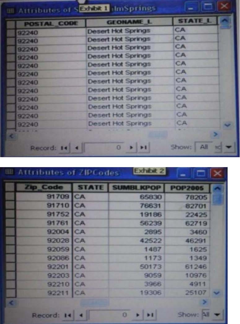
An ArcGIS user is attempting to create a relationship class between the two tables shown in the exhibit using POSTAL_CODE and Zip Code as the origin primary key and destination foreign Keys, respectively. However when the user tries to set the keys zip Cede does not appear in the drop-down list of candidate keys.
What should the user do to successfully create the relationship class?
A. change the relationship type from non attributed to attributed
B. make sure both tables are in the same geodatabase
C. create data type compatible key fields
D. move both tables to the same feature dataset
-
Question 30:
An ArcGIS user needs to classify 25 different vegetation types. The user has a single band. 20- meter resolution image with 10-meter spatial accuracy. Which type of accuracy is the data lacking?
A. Horizontal
B. Spectral
C. Vertical
D. Spatial
Related Exams:
EADA10
ArcGIS Desktop AssociateEADA105
ArcGIS Desktop Associate 10.5EADE105
ArcGIS Desktop Entry 10.5EADE19-001
ArcGIS Desktop Entry 19-001EADP10
ArcGIS Desktop ProfessionalEADP19-001
ArcGIS Desktop Professional 19-001EGMA105
Enterprise Geodata Management Associate 10.5EGMP2201
Enterprise Geodata Management Professional 2201ESRI-EADA
ArcGIS Desktop AssociateESRI-EADP
ArcGIS Desktop Professional 19-001
Tips on How to Prepare for the Exams
Nowadays, the certification exams become more and more important and required by more and more enterprises when applying for a job. But how to prepare for the exam effectively? How to prepare for the exam in a short time with less efforts? How to get a ideal result and how to find the most reliable resources? Here on Vcedump.com, you will find all the answers. Vcedump.com provide not only Esri exam questions, answers and explanations but also complete assistance on your exam preparation and certification application. If you are confused on your EADP19-001 exam preparations and Esri certification application, do not hesitate to visit our Vcedump.com to find your solutions here.