Exam Details
Exam Code
:EADP19-001Exam Name
:ArcGIS Desktop Professional 19-001Certification
:Esri CertificationsVendor
:EsriTotal Questions
:93 Q&AsLast Updated
:Jun 30, 2025
Esri Esri Certifications EADP19-001 Questions & Answers
-
Question 51:
An ArcGIS user wants to create a hierarchy and differentiate cities on a map by categorizing the way the features are labeled. What should be used to achieve the desired result?
A. label expressions
B. label classes
C. label stacking
D. label priority
-
Question 52:
An ArcGlS user decides to use labels in a map document because the annotation appears pixelated as the user zooms from the reference scale.
What Is a potential effect of this decision?
A. Label placement will be controlled by the user
B. Text placement will become static
C. Labels will only draw at the reference scale
D. The map will render more slowly
-
Question 53:
An ArcGlS user has a point feature class and needs to determine whether there are anyspatial outliers. For this project, a spatial outlier is defined as any feature that is greater than one standard deviation from the mean center of the features.
Which Spatial Statistics geoprocessing tool should be used to accomplish this task?
A. Average Nearest Neighbor
B. Central Feature
C. Mean Center
D. Standard Distance
-
Question 54:
An ArcGIS user is given a geodatabase and tasked with adding a feature class to an existing geodatabase topology. What should the user do?
A. delete the existing geodatabase topology and create a new one to include the feature class
B. modify the existing geodatabase topology to include the feature class Explanation:- https://desktop.arcgisxom/en/arcmap/10.3/tools/data-m
C. export the existing geodatabase topology to an XML file include the feature class in the XML and import it
D. remove all the feature classes from existing topology and add everything back including the feature class that needs to be added
-
Question 55:
Refer to the exhibit.
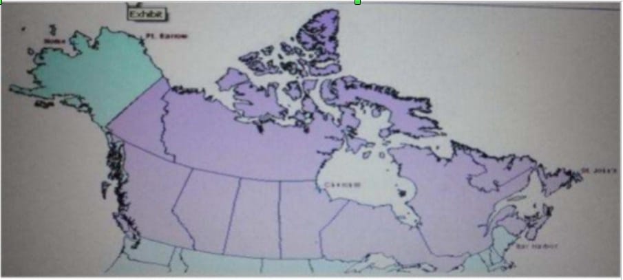
The ArcGIS user is given data for the Arctic, and is asked to perform various types of analysis using the data. The data extends from the North Pole south to 55 degrees North Latitude Data layers may contain points lines, or polygons and include ice surveys from NOAA depth contours; continental margins, locations of known and suspected oil reserves, endangered species habitat and territorial boundaries for nations having Arctic coastline.
An ArcGIS user is asked to calculate the distance a cruise ship will travel through open water, departing from Nome, Alaska, with stops at Point Barrow Alaska Churchill Manitoba St John's Newfoundland and ending in Bar Harbor Maine. On
the basis of these calculations the cruise ship line will determine fuel requirements and travel time.
Which map projection yields the most accurate results for this distance calculation?
A. Albers equal area conic
B. Lambert azimuthal
C. Mercator
D. azimuthal equidistant
-
Question 56:
A tax preparation company completes a quarterly cleaning of their records. Using a Python script they automate the deletion of records that are more than seven years old or records for customers who have not been seen in more than five years.
When using a cursor function, what deletes the appropriate records?
A. a search cursor and the deleteRow method
B. an insert cursor and the deleteRow method
C. an update cursor and the deleteRow method
D. a find cursor and the deleteRow method
-
Question 57:
An ArcGis user is making a small-scale map using road data that was collected at a large scale. What is the appropriate tool for removing some of the road detail?
A. Thin Road Network
B. Simplify Line
C. Collapse Dual Lines to Centerline
D. Smooth Line
-
Question 58:
A water utility company had received calls fromseveral customers complaining oflow water pressure.
Using a geometric network representing the water network, how can an ArcGIS user determine the most likely location of the problem?
A. place junction flags on each customer water meter and use the Find Common Ancestors trace task
B. place junction flags on each customer water meter and use the Find Disconnected trace task
C. place a junction barrier on each customer water meter and use the Trace Upstream trace task
D. place a junction barrier on each customer water meter and use the Find Path upstream trace task
-
Question 59:
A school bus dispatcher needs to create a bus route that stops at student homes during specific time ranges. Which Network Analyst setting should the dispatcher use to accomplish this task?
A. Impedance Time
B. Time Windows
C. Start Time
D. Time Accumulation
-
Question 60:
In the Feature Class to Feature Class tool which parameter allows an ArcGlS user to manipulate attributes to be included the output feature class table?
A. input features
B. SQL expression
C. configuration Keyword
D. field mapping
Related Exams:
EADA10
ArcGIS Desktop AssociateEADA105
ArcGIS Desktop Associate 10.5EADE105
ArcGIS Desktop Entry 10.5EADE19-001
ArcGIS Desktop Entry 19-001EADP10
ArcGIS Desktop ProfessionalEADP19-001
ArcGIS Desktop Professional 19-001EGMA105
Enterprise Geodata Management Associate 10.5EGMP2201
Enterprise Geodata Management Professional 2201ESRI-EADA
ArcGIS Desktop AssociateESRI-EADP
ArcGIS Desktop Professional 19-001
Tips on How to Prepare for the Exams
Nowadays, the certification exams become more and more important and required by more and more enterprises when applying for a job. But how to prepare for the exam effectively? How to prepare for the exam in a short time with less efforts? How to get a ideal result and how to find the most reliable resources? Here on Vcedump.com, you will find all the answers. Vcedump.com provide not only Esri exam questions, answers and explanations but also complete assistance on your exam preparation and certification application. If you are confused on your EADP19-001 exam preparations and Esri certification application, do not hesitate to visit our Vcedump.com to find your solutions here.