Single choice
In the Feature Class to Feature Class tool which parameter allows an ArcGlS user to manipulate attributes to be included the output feature class table?
Reveal answer details Close answer details
Correct answerD
Esri · EADP19-001
Preview real exam questions, verified answers and available explanations before choosing a study plan.
|
Single choice
In the Feature Class to Feature Class tool which parameter allows an ArcGlS user to manipulate attributes to be included the output feature class table? Reveal answer details Close answer detailsCorrect answerD
Single choice
Four emergency response facilities need to be placed so that the greatest number of people in a community can be reached within five minutes. Which analysis method is used to make this determination? Reveal answer details Close answer detailsCorrect answerA
Single choice
An ArcGIS user receives a drawing file created in AutoCAD, and is told the data is in NAD 1983 State Plane coordinates. When compared with data for the same area, the .dwg file is too big. Which property of the data should the ArcGIS user check first? Reveal answer details Close answer detailsCorrect answerB
Single choice
An analyst has a multi band raster, but needs just one of the bands for a project. Which geoprocessing tool should be used to extract a single band? Reveal answer details Close answer detailsCorrect answerC
Single choice
Using street data for a large metropolitan area, which analysis method shows the nearest hospital to a traffic accident? Reveal answer details Close answer detailsCorrect answerA
Single choice
A geodatabase designer has a requirement that individual spot elevation points, contours, and a digital elevation model be stored as separate layers and also be used to generate a surface for visibility analysis. Which geodatabase dataset type should the designer use? Reveal answer details Close answer detailsCorrect answerD
Single choice
An ArcGIS user is tasked with publishing an image service out of a collection of rectified satellite imagery. Which method of recomputing footprints accomplishes this? Reveal answer details Close answer detailsCorrect answerB
Single choice
An ArcGis user is making a small-scale map using road data that was collected at a large scale. What is the appropriate tool for removing some of the road detail? Reveal answer details Close answer detailsCorrect answerB
Single choice
A geometric network has been removed from a feature dataset. What must happen to the geodatabase to avoid synchronization failing? Reveal answer details Close answer detailsCorrect answerB
Single choice
An ArcGIS user regularly receives a large volume of data in shaped le coverage, and table formats. The user has a Python script tool for converting the data to a standard feature class format and writing it into a file geodatabase. The user schedules the script to run automatically, based on the update schedule, but the tool is sometimes unable to write to the database. Why is the tool sometimes unable to write to the database? Reveal answer details Close answer detailsCorrect answerA
Single choice
The ArcGIS user is given data for the Arctic and is asked to perform various types of analysis using the data. The data extends from the North Pole south to 70 degrees North Latitude Data layers may contain points lines, or polygons, and include ice surveys from NOAA depth contours: continental margins, locations of known and suspected oil reserves, endangered species habitat, and territorial boundaries for Which map projection should be used for the data to allow the most accurate buffering of those areas, in order to comply with the U.S court decision that ships may not approach closer than 20 nautical miles to a seal rookery? Reveal answer details Close answer detailsCorrect answerC
Single choice
Given an elevation surface, a raster of forest stands, and a point feature class of saw mills, which analysis is used to determine the optimal route from each forest stand to the nearest saw mill? Reveal answer details Close answer detailsCorrect answerD
Single choice
Refer to the exhibits. 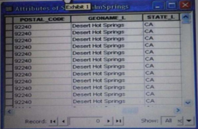 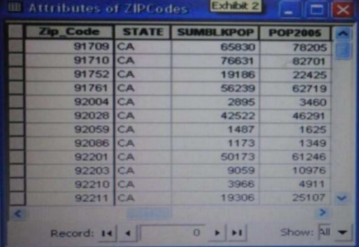 An ArcGIS user is attempting to create a relationship class between the two tables shown in the exhibit using POSTAL_CODE and Zip Code as the origin primary key and destination foreign Keys, respectively. What should the user do to successfully create the relationship class? Reveal answer details Close answer detailsCorrect answerB
Single choice
While attempting to geocode schools within a 20-mile of a museum, an ArcGIS user realizes that the table they are trying to geocode only contains the names of the schools. Which type of table should the user link to their address locator in order to efficiently display the locations of the schools? Reveal answer details Close answer detailsCorrect answerB |